防災Disaster Prevention
安全・安心・持続可能な社会を実現するために、洪水氾濫や土砂災害などの自然災害を対象にその発生危険性や影響範囲の予測・評価を行う各種予警報システムの開発を行います。
災害発生の予測技術と最新のセンシング・通信・計算制御・Web技術を駆使して、データ受信・解析処理・結果表示・配信といった一連の処理を24時間365日リアルタイムに行える統合防災システムを構築します。
In order to realize a safe, secure, and sustainable society, we develop various types of disaster prediction and warning systems to predict and evaluate the risk and impact of natural disasters, such as floods and landslides.
We will build an integrated disaster prevention system that can perform a series of processes, such as data reception, analysis processing, result display, and distribution, in real time, 24 hours a day, 365 days a year, using disaster forecasting technology and the latest sensing, communication, computational control, and Web technologies.
分布型洪水予測システム
Distributed Flood Prediction System
リアルタイムに稼働する分布型洪水予測システムの設計・構築や既存システムの改良を行うことが可能です。提案するシステムは、河川防災のほか、例えばダムモデルを組み込んで利水の流況予測やダム操作の高度化支援などにも活用できます。
We can design and construct a distributed flood forecasting system that can operate in real time or improve existing systems. In addition to river disaster prevention, the proposed system can also be used for predicting water utilization and supporting advanced dam operations by incorporating a dam model, for example.
技術特長
Technical Features
- 流域特性を考慮した計算モデルの作成から、パラメータ最適化、水文気象情報の受信処理、リアルタイム予測計算の実行、予測結果の可視化・伝達、システムの設計・開発・インストールまで一貫して対応可能
- 各種流出解析モデル(分布型、タンクモデル、貯留関数、Kinematic Wave、Diffusion Wave、Dynamic Waveなど)に対応
- 自社開発の計算プログラムを保有するため、ダム操作、積雪・融雪、潮位等各種シミュレーションや粒子フィルターによるデータ同化と組合せで予測計算モデルの開発が可能
- リアルタイム予測機能のほか、フィードバック、再現計算、シミュレーション計算、代表出水の自動抽出・保存などの機能を具備
- We can create a calculation model that considers watershed characteristics, optimize parameters, receive and process hydro-meteorological information, perform real-time forecast calculations, visualize and communicate forecast results, and design, develop and install a system.
- Support for various runoff analysis models (distributed, tank model, storage function, Kinematic Wave, Diffusion Wave, Dynamic Wave, etc.)
- Since we have our own calculation programs, we can develop predictive models in combination with various simulations of dam operations, snow and snowmelt, tide levels, etc., and data assimilation by particle filters.
- In addition to real time prediction, it has functions such as feedback, replication and simulation calculations, and automatic extraction and storage of representative effluent.
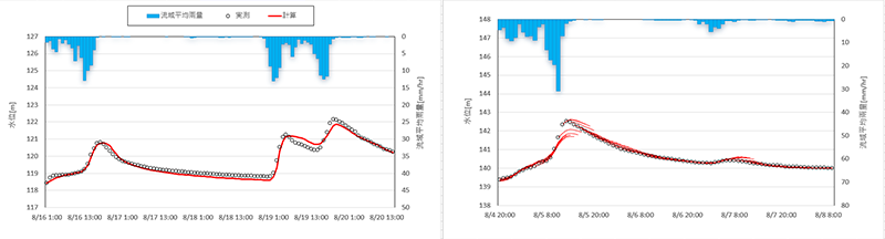
左:分布型モデルによる再現計算の例、右:分布型モデルによる6時間先までの予測計算の例
Left: Example of a reproduction calculation using a distributed model; Right: Example of a prediction calculation up to 6 hours ahead using a distributed model
土砂災害警戒避難システム
Landslide Disaster Warning and Evacuation System
地形、地質、土地利用等のデータを用いて、降雨や地震による土砂災害の発生位置・時間・規模をリアルタイムに予測し、早期避難に資する情報を配信する土砂災害警戒避難システムを構築します。
We are developing an evacuation warning system that can predict the location, time, and scale of landslides caused by rainfall and earthquakes in real time using topographical, geological, land use, and other data to distribute information that contributes to early evacuation.
技術特長
Technical Features
- レーダ解析雨量を用いた降雨の飽和・不飽和浸透解析、表面流・地中流の水理計算、土層飽和度の変化や地下水位の上昇を考慮した斜面安定解析などの自然現象を忠実に反映できる高精度な物理モデルを採用
- 広範囲の対象流域を同一な地形・地質条件を有する斜面単位(Slope Unit)に分けて、斜面単位ごとに安全率の確率分布より崩壊危険度の評価
- 3次元斜面安定解析モデルのモンテカルロシミュレーションにより、未知な危険すべり体の位置および規模を推定
- Highly accurate physical models that faithfully reflect natural phenomena, such as saturated and unsaturated infiltration analysis of rainfall using radar analysis rainfall, hydraulic calculations of surface and underground flows, and slope stability analysis taking into account changes in soil layer saturation and groundwater level rise.
- Evaluate the degree of risk of failure based on the probability distribution of safety rates for each slope unit by dividing the wide area of target basins into slope units with the same topographical and geological conditions (Slope Unit)
- Estimation of the location and size of unknown hazardous slips by Monte Carlo simulation of a 3D slope stability analysis model
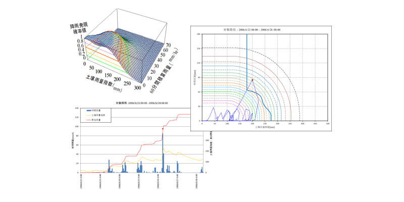
土砂災害警戒情報の判定基準雨量(CL)の設定
Establishment of Critical Line for Determination of Landslide Warning Information (CL)
都道府県と気象台が共同で発表する土砂災害警戒情報について、国土交通省と気象庁より公表する手引きに基づき、その判定基準雨量(CL:Critical Line)の設定・見直し・検証を行います。
In accordance with the guidelines published by the Ministry of Land, Infrastructure, Transport and Tourism and the Japan Meteorological Agency, we set, review and verify the critical line (CL) for sediment-related disaster warnings issued jointly by local governments and meteorological observatories.
技術特長
Technical Features
- 土壌雨量指数データの高解像度化(5kmメッシュから1kmメッシュへ)に対応可能
- RABやGRIB2形式のレーダ雨量・土壌雨量指数データのデコード処理から、CL対象災害の選定、RBFN応答曲面の作成、CLの設定・見直し検討(下限値や除外格子の設定を含む)、各種検証指標の算出、スネーク図の作成、気象台用のマスターデータの作成までのすべての業務内容に対応可能。
- Support for higher resolution soil rainfall index data (from 5 km mesh to 1 km mesh)
- All services from the decoding of radar rainfall and soil rainfall index data in RAB and GRIB2 formats, selection of hazards for CL, preparation of RBFN response surfaces, setting and review of CLs (including setting of lower limits and exclusion grids), calculation of various verification indices, preparation of snake maps, and preparation of master data for the weather station. It is possible to respond to the content.